General goals
- Preserve Mount Royal ’s symbolic value, public access,
natural environment and landscapes
- Protect and enhance the area’s built, natural and
archaeological heritage
- Improve connections between Mount Royal and adjacent areas
Planning issues
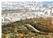
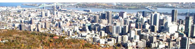
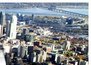
The Montréal skyline is dominated by Mount Royal. The City’s urban configuration stems, in large part, from the presence of the Mountain with its three summits. Mount Royal is both a landmark and a symbol of the City, deeply rooted in the history and the consciousness of the Montréal community.
Considered a place of prestige, the slopes of Mount Royal were gradually urbanized, starting in the 19th century. Mount Royal Park, which was officially created in 1876, turned the Mountain into a destination to be enjoyed not only by residents, but also by tourists: a place to rest and relax, to practice recreational activities, to observe plants and animals and to take in the panoramic views of the City and the river. This major green space also includes the Notre-Dame-des-Neiges and Mount Royal cemeteries. The enhancement of this unique area must take into account the diversity of its features and the components of its landscape: memorial, heritage, natural and archaeological sites, public and funeral art, woods and bird sanctuaries such as Summit Park.
In 1988, the Ville de Montréal created the Mount Royal heritage site. To preserve the park, projects respecting the spirit that guided its creation and design by Frederick Law Olmsted have been carried out and still more are to come.
A considerable amount of work has been done since the adoption of the Plan de mise en valeur du mont Royal (Mount Royal Enhancement Plan) in 1992. However, and the Plan needs to be updated to include new concerns, for instance the protection of heritage landscapes. Innovative protective measures and the introduction of environmental management methods are also required, especially since this is an ecoterritory with specific conservation and development objectives. Furthermore, the potential expansion of major institutions, convents, schools and hospitals or their conversion to other uses, as well as changes to the landscape, should be taken into account, as should the necessity of preserving views of Mount Royal from various parts of the City. In addition, work to mitigate the impact of visitors is necessary in certain fragile areas.
The physical connections between Mount Royal and the City
warrant an in-depth review. Although the Mountain is encircled by major thoroughfares, pedestrian and bicycle access lacks legibility and comfort. Some redevelopment projects are planned, including the dismantling and redesign of the Avenue du Parc/Avenue des Pins and Chemin Remembrance/ Chemin de la Côte-des-Neiges interchanges. Access by public transit and for tourists should be considered as well as the Mountain’s parking issues.
Finally, its status as a historic and natural district, conferred by the government of Québec, overlaps the administrative boundaries of the boroughs and adds another dimension to the planning and management of this exceptional site. These must be integrated and undertaken in cooperation with all stakeholders: citizens, conservation groups, major institutions and the Québec government.