The Société du Havre de Montréal, created at the initiative of the Ville de Montréal and the Canadian and Québec governments in the wake of the 2002 Summit, is responsible for the preparation of the integrated development scheme for the Havre de Montréal, as well as an implementation and funding strategy. Given the complexity of the issues and the numerous stakeholders, only this type of organization can bring together the main institutional and economic actors to develop a shared vision. Thus, detailed planning for the Havre de Montréal area is very much underway.
General goals
- Make the Havre de Montréal a model of urban design
and sustainable development, realizing its full potential in terms of
recreational, tourism, residential, industrial and port activities
- Improve the Havre’s image as the major gateway to the
Central Business District and give it a prestigious character
- Restore Montrealers’ access to the St. Lawrence River
and its banks by substantially improving the accessibility of the area
- Protect and enhance the built, natural and
archaeological heritage
- Mitigate environmental nuisances
Planning issues
The Havre de Montréal has witnessed numerous phases of Montréal’s development. The port, railway and industrial environments are now undergoing radical change, resulting in the consolidation or withdrawal of various economic activities. The uncertain future of the Canadian National railyard in Pointe-Saint-Charles illustrates this situation.
The Havre’s renaissance over the past 40 years is due to major international recreational, tourism, cultural and sports events, such as the creation of Parc Jean-Drapeau and the opening of the Casino, the redevelopment of the Old Port and, more recently, the renewal of Old Montréal as a residential neighbourhood along with the reopening of the Lachine Canal and the emergence of the Cité Multimédia and the Quartier international. This evolution has resulted in the sometimes difficult cohabitation of multiple uses and the availability of many lots for development purposes.
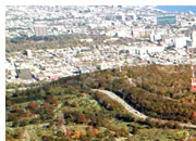
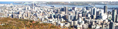
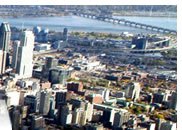
The area has a number of undeniable assets. Among them are its exceptional viewscapes and the presence of the St. Lawrence River, which combine to make the Havre de Montréal a place of unequalled prestige. The Old Port opened the first window onto the river, but development of the waterfronts and wharves throughout the area needs to be completed and their accessibility improved, in order to achieve more contact with the river and take full advantage of its presence.
The location of the Autoroute Bonaventure currently prevents any access to the river or its banks. The imposing profile of its elevated section has a major visual impact. The Expressway also creates another restriction: even though it facilitates access to the Central Business District from the South Shore, it does not adequately serve the employment areas along its length.
The Expressway is also used by a large number of buses coming from the South Shore via the reserved bus lane on the Champlain Bridge. This lane, which operates in the direction of oncoming traffic, raises safety issues.
Poor public transportation in the Havre area is a major impediment to the harmonious development of its functions and an obstacle to optimizing its recreational and tourism facilities. It leads many visitors to drive to the Old Port, Parc Jean-Drapeau and the Casino. This traffic causes major nuisances for residents of Old Montréal and the Cité du Havre. In addition, automobile traffic and the presence of large parking lots on the islands are at odds with their vocation as parks.
A large part of the area has significant heritage value. The conservation of these heritage elements must be carefully analyzed, however. For instance, the renovation of Grain Elevator No. 5 must be incorporated into the reorganization of the adjoining industrial and port space, even though the size and nature of the structure make this a complicated undertaking. Île Sainte-Hélčne and Île Notre-Dame contain sites of military heritage (the fort, tower and cemetery) and major modern heritage dating from Expo 67. The Jacques-Cartier Bridge and the woods on Île Sainte-Hélčne also have significant heritage value.
On the other hand, certain sections of the area pose serious environmental problems. The land along the Autoroute Bonaventure is a former landfill site whose soil is both unstable and contaminated by toxic industrial waste. The lands currently used for industrial, railway and port purposes may also be contaminated.
In summary, various stakeholders with different interests are transforming the area. In order to ensure its harmonious development, new uses and the sequence of their implementation must be determined strategically.