11
Enhance Mount Royal, the island character and other major features of the City's identity
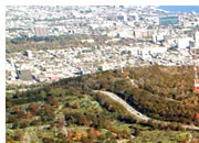
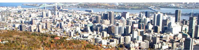
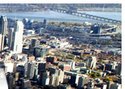
The predominance of Mount Royal and the Central Business District's (CBD) skyline are important symbols of Montréal. The territory's island character and the visual presence of the St. Lawrence and other rivers, canals and lakes surrounding the City also rank among the key features shaping its identity.
From the earliest days of European settlement, the City's island location generated a series of thoroughfares that follow a virtually uninterrupted course along the riverbanks. Today, this waterside roadway is not only scenic, but also historical, recreational, residential and rural, while encompassing the port and industrial activities.
In addition to Mount Royal 's central position, Montréal's urban landscape is characterized by an extensive green network consisting of tree-lined streets, parks and green spaces.
Even today the urban landscape and general layout of Montréal's street pattern remain closely tied to the original pattern of côtes and montées established in the 17th and 18th centuries, as well as to the natural physical features of the landscape.
The City's gateways, including the bridges and their approaches, also provide unique opportunities for Montréal to assert its identity.
Montréal's urban landscape also reveals itself at night. The different uses of light - for utility, advertising or atmosphere - represent various ways of enriching the urban landscape and developing Montréal's nocturnal signature.
The Plan sets seven actions relative to enhance Mount Royal, the island character and other major features of the City's identity:
| 11.1 |
 |
Preserve the character of Mount Royal and its predominance in the urban landscape
|
|
| 11.2 |
|
Assert Montréal’s island character and enhance its waterside roadway
|
|
| 11.3 |
|
Preserve and improve Montréal’s green network
|
|
| 11.4 |
|
Preserve and enhance rural character and agricultural activities in certain areas of the West Island
|
|
| 11.5 |
|
Preserve the specific features of Montréal’s urban framework
|
|
| 11.6 |
|
Highlight the gateways to Montréal’s territory
|
|
| 11.7 |
|
Highlight Montréal’s nightscape
|
|